Quadtree in System Design
Monday, January 8, 2024
Efficiency is critical in the complex world of geographical data representation. Enter the quadtree, a hierarchical tree structure that excels in geographical data organization and management. The quadtree is a great tool for bringing order to complexity, whether you’re working with graphics, maps, or geographic information systems. In this blog article, we’ll look at the quadtree’s magic and how it optimizes spatial data operations.
Understanding Quadtree: The Foundation
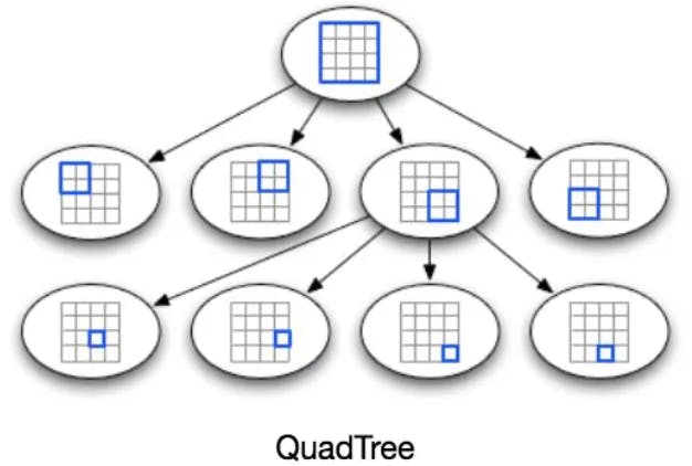
A quadtree is, at its core, a tree data structure in which each internal node has exactly four offspring. The quadtree’s beauty comes in its capacity to partition a space into quadrants recursively until a given condition is met. This hierarchical technique enables for effective spatial data organization and retrieval.
Quadrants and Nodes
Consider dividing a rectangle into four equal quadrants. Each quadrant creates a child node, and the process is repeated recursively. As a result, each node represents a square region of space, and each leaf node includes specialized spatial data.
Application Examples:
Image Storage and Compression
Quadtree architectures shine in image processing applications such as image compression. The quadtree can depict areas of uniform color with a single node by dividing an image into quadrants. This hierarchical compression saves storage space while maintaining image quality.
Game Collision Detection
Quadtrees are used for collision detection in the gaming world, where milliseconds are critical. The technology can instantly anticipate potential collisions, optimize gameplay, and improve the gaming experience by organizing game elements into hierarchical frameworks.
Geographic Information Systems (GIS)
Quadtrees are essential in GIS applications. The hierarchical precision of quadtrees enables swift and efficient queries, whether you’re searching for places of interest on a map or analyzing spatial relationships. They organize the massive datasets that are inherent in geographic information systems.
A Simple Example of a Quadtree
Consider a map representation of a city. It is possible to efficiently store and retrieve spatial data for different elements, such parks, roads, and buildings, using a quadtree. The quadtree constantly adapts as you zoom in, giving more information in particular areas while preserving a broad picture.
Advantages:
Effective Geographical Searches
For spatial queries, quadtrees are excellent. With every level of recursion, the search space is drastically shrunk because to the hierarchical structure of quadtrees, which is useful for both spatial relationship analysis and nearby location searches.
Ability to Adjust to Dynamic Data
Quadtrees perform well in dynamic contexts where the spatial data is dynamic. They are appropriate for real-time applications because of their capacity to adjust to changing datasets and their effectiveness in insertion and deletion processes.
Final Thoughts: Handling Spatial Complexity
The quadtree appears as a guiding star as we traverse the complicated terrain of spatial data, providing efficiency and order to problems in system design. The hierarchical precision of the quadtree is invaluable for several applications such as image compression, geographic information organization, and gaming experience enhancement. Thus, keep in mind the quadtree’s strength the next time you’re deciphering the complexities of spatial data — a hierarchical marvel that maximizes efficiency while simplifying complexity.
You can also appreciate this blog post through my medium account.